Apr
3
2008
 Buckhorn Wash (San Rafael Swell)
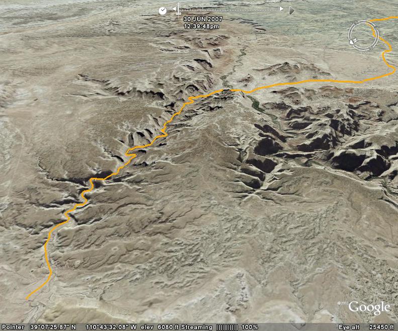
Buckhorn Wash is a very easy graded road through the heart of the San Rafael Swell north of Interstate 70. In dry conditions, a passenger vehicle would have no issues navigating this road. This road is easy to access from I-70.
While this road is not challenging, it does offer some excellent scenery and history along the route, including Indian rock art and dinosaur tracks. There is even an inscription from the infamous Matt Warner.
This road also can take you to a number of other trails in the northern part of the Swell including The Wedge Overlook, Swasey’s Leap and Mexican Bend. You can spend a lot of time exploring this area.
Please feel free to leave your comments and post your pictures from Buckhorn Wash below.
 Buckhorn Wash KML Track
(Right click and ‘Save Target As’)
Open file above in Google Earth.
Comments Off on Buckhorn Wash | posted in Trails
Apr
2
2008
 Engineer Pass (Silverton, CO)
Engineer Pass is part of the famous Alpine Loop when combined with Cinnamon Pass. This loop is a ‘must do’ trail for anyone visiting the San Juan Mountains. Engineer Pass is the more difficult of the two trails in the loop and but should easily be traversed by any stock 4×4 with decent ground clearance.
The beginning of this trail is a bit bumpy and rocky but smooths out after the pass. The first five miles of the trail are the most difficult, and you will need to navigate some shelf roads here, too. There are a number of old mines and other historical points of interest to explore while traversing this route.
Before you get to Engineer Pass, which tops out at 12,750 feet, you will want to take the short drive out to Oh! Points for amazing views and great photo opportunities.
Please feel free to leave your comments and post your pictures from Engineer Pass below.
 Engineer Pass KML Track
(Right click and ‘Save Target As’)
Open file above in Google Earth.
1 comment | posted in Trails
Mar
28
2008
 Chicken Corners (Moab, Utah)
Chicken Corners trail starts at Hurrah Pass and then gradually winds it’s way down to the Colorado River which it follows for a while with some great views.
Most of this trail is easy, but there are a few rocky spots that might require a high clearance 4×4 vehicle. After running this trail you can also access Lockhart Basin on your way back if you are interested in making this trail part of a multi-day trip.
Dead Horse State Park is located directly across the Colorado River from the end of this trail. There is a very narrow footpath at the end of this trail, but I certainly was not brave enough to try it.
Please feel free to leave your comments and post your pictures from Chicken Corners below.
 Chicken Corners KML Track
(Right click and ‘Save Target As’)
Open file above in Google Earth.
1 comment | posted in Trails
Mar
27
2008
 Cinnamon Pass (Silverton, Colorado)
Cinnamon Pass is part of the famous Alpine Loop when combined with Engineer Pass. This loop is a ‘must do’ trail for anyone visiting the San Juan Mountains. Cinnamon Pass is the easier of the two trails in the loop and can easily be traversed by any stock 4×4 with decent ground clearance.
This trail is a very relaxing drive with spectacular scenery. This pass tops out at an elevation of 12,640 feet and offers a nice view of the switchbacks heading back down into the valley after the pass.
When you are done with the Alpine Loop and end back up at Animas Forks, there are a number of other trails that you can follow from there including California Pass and Placer Gulch. Or you can just head back to Silverton and wander around that interesting town.
Please feel free to leave your comments and post your pictures from Cinnamon Pass below.
 Cinnamon Pass KML Track
(Right click and ‘Save Target As’)
Open file above in Google Earth.
1 comment | posted in Trails
Mar
27
2008
 Onion Creek (Moab, Utah)
Onion Creek is a very scenic ride that pretty much any 4×4 vehicle can handle. At the start of the trail there are a bunch of creek crossings. If it has recently rained, be careful because the crossings can get high. The trail often washes out and flash flooding is possible.
Driving this trail is very relaxing and winds it’s way through a beautiful deep-cut canyon with plenty of opportunities for photographs. There are also a number of campsites along the trail if you are looking for a place to spend the night.
When you are done exploring Onion Creek, you can head North on highway 128 for less than a mile and turn right to head to Fisher Towers.
Please feel free to leave your comments and post your pictures from Onion Creek below.
 Onion Creek KML Track
(Right click and ‘Save Target As’)
Open file above in Google Earth.
1 comment | posted in Trails
![]() Buckhorn Wash KML Track
Buckhorn Wash KML Track


